Dupitila Fm
Type Locality and Naming
P Evans named it after the Dupi Tila hills in the Hari (Shari) river (25°06'N; 92°08'E) valley of Sylhet district. [Original Publication: Evans, P. (1932) Tertiary succession in Assam, Trans. Min. Geol. Inst, India, Vol. 27, pp: 173-200.]. Reference section: Hills between Chargola and Langai Valleys.
Synonyms: Dupi Tila Fm. The coarse ferruginous sandstones with clay interbeds overlying Tipam Series and unconformably overlain by Dihing Series were classified as Dupitila beds by Evans (1932). However in the accompanying stratigraphic charts, Evans designated this unit as a stage. This unit was named after Dupitila. Later, Wilson and Metre (1953) elevated its status to series and divided it into Lower and Upper Dupitila stages. Subsequently, Mathur and Evans (1964) retained the latter classification. The Dupitila is given the rank of formation by Deshpande et al (1993).
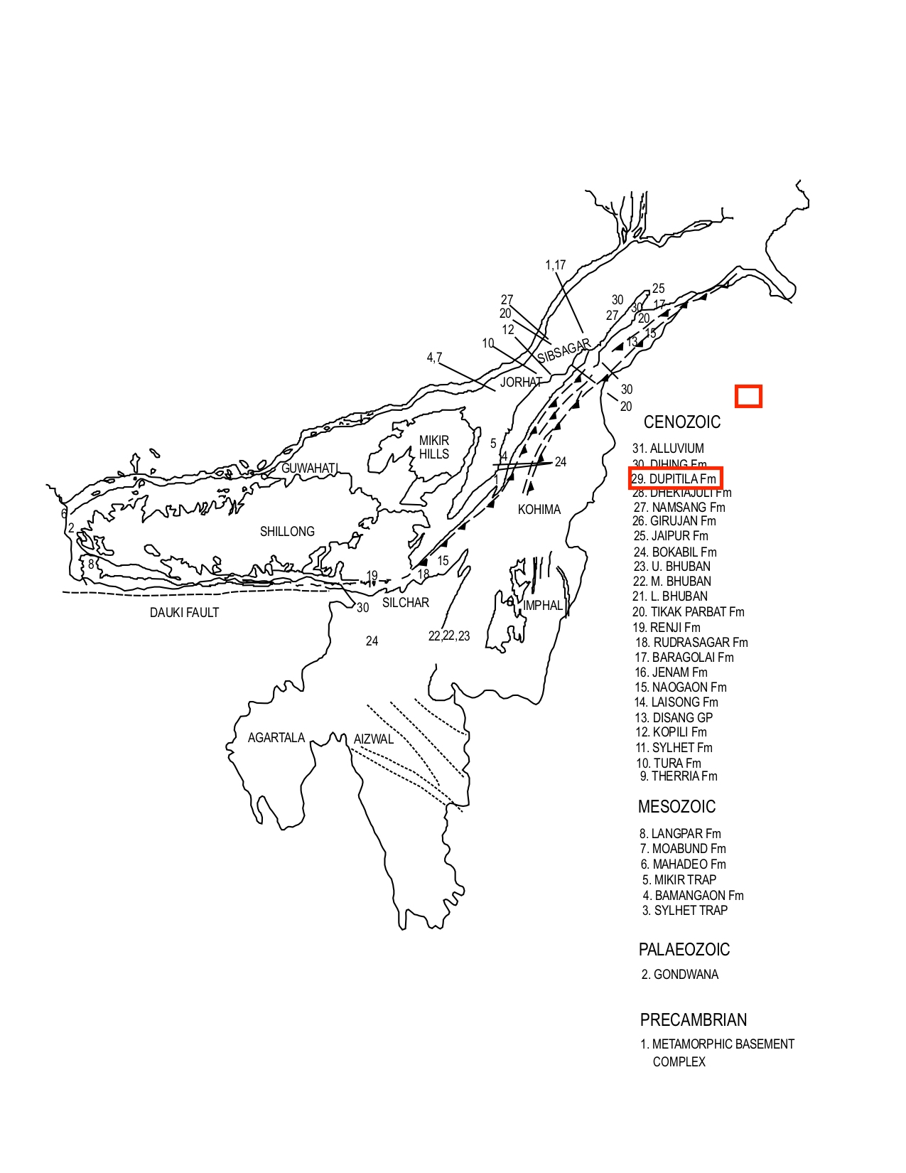
[Figure 1: Geological set up and formation stratotypes of North East Basins (modified after Pandey and Dave, 1998)]
Lithology and Thickness
Sandstone. In the type section, the Dupitila Fm consists of coarse, ferruginous sandstones with numerous layers of grits. These sandstones are interbedded with sandy clays and clays. In reference section, the section exposed between Langai and Chargola valleys consists of interbedded sandstones and mottled clays often sandy. In Sylhet, the formation consists of two distinct units. The Lower part is composed chiefly of massive sandstone interbedded with subordinate claystone. The sandstone is yellow to yellowish brown, medium to coarse, cross-bedded and in places pebbly. The Upper part consists of claystone and siltstone with subordinate sandstone.
In Chittagong, the Dupitila Fm consists of yellowish-brown to brown, fine to medium grained pebbly and cross-bedded sandstone with subordinate claystone and siltstone. In the subsurface of northern Bangladesh the formation consists of pebble beds, coarse to fine-grained sandstone and shale of grey colour. Well preserved leaf impressions in Dupitila sandstones are also reported from Kaptai Lake near Rangamati. In the Chittagong-Cox's Bazar area the unit contains pockets of white clay, though white clay beds are found in the same formation in Mymensingh district. Folding and faulting were common during deposition of this unit and extremely thick sequences were deposited in the rapidly subsiding areas. The thickness along the Hari river in Sylhet is about 1,722 m, in the Goyain and Kushiara troughs 4,419 m and 3,669 m, and in the subsurface of northern Bangladesh ranges from 20 to 276 m. South of the Shillong Plateau, the thickness of Dupitila Formation ranges between 825 to 1067 m (Roy Barman and Nahar, 1968). In the subsurface of Tripura-Cachar area its maximum thickness is 1350 m in the well Gobindpur-1
Relationships and Distribution
Lower contact
The Dupitila Fm unconformably overlies Gobindpur Fm of Tipam Gr in the Tripura-Cachar Fold Belt or unconformably overlies undifferentiated Tipam Gr in Southeast Khasi and Jaintia Hills. In SE Bangladesh, it unconformably overlies either the Girujan Fm Clay. It also unconformably overlies undifferentiated Surma Gr in West Khasi and Garo Hills. At Atgram, the unit overlies the Bokabil Fm.
Upper contact
It unconformably overlain by Dihing Fm or alluvial cover (called Alluvium Fm here for linking purposes). In the Tripura-Cachar Fold Belt and Garo and West Khasi Hills, whereas it is unconformably overlain by alluvial (called NEBasinAlluvium Fm here for linking purposes) in south-east Khasi and Jaintia Hills.
Regional extent
Garo Hills, Khasi & Jaintia Hills, Mikir Hills, Tripura-Cachar, SE Bangladesh: The Dupitila exposures are restricted in their occurrence to Surma Valley along the foothills of South Shillong Plateau. It is exposed in Chittagong division as well as along the southern margin of the Jaintia hills of Assam and Bangladesh. In northern Bangladesh the presence of the unit has been reported from a number of drill holes.
GeoJSON
Fossils
No detailed paleontological or palynological studies are available.
Age
Depositional setting
Additional Information
Banglapedia (National Encyclopedia of Bangladesh as compiled by several geologists; http://en.banglapedia.org/index.php/Geological_Group-Formation; 2015)
